
During my senior year of college, three friends and I took an epic road trip. While everyone else went “down south” to Florida for spring break, we Florida college kids decided to head north to Tennessee.
It was legen-waitforit-dary!
We saw snow. We toured Graceland. We broke down in Alabama. We visited a Civil War Museum. We partied in Nashville. We saw mountains. We sang in bars. We visited grad schools. We drove across the Mississippi River to Arkansas-- to see 89-cent gasoline (I took a picture!)
It was so much fun!
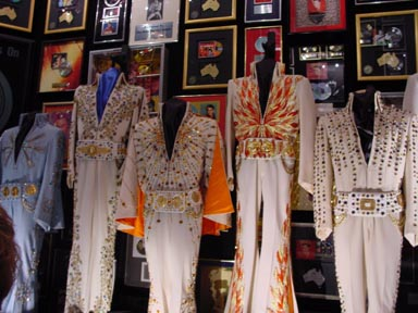 I’m such a history dork. I loved being in Elvis Presley's house and seeing all his awesomely-sequined outfits and the famed “jungle room”. I loved peeking into the Ryman Auditorium in Nashville and seeing where so many country music artists performed. I loved stopping at random historical markers on the side of the road and learning about Civil War marches or early English settlers or inventions created.
There is a lot of history that has happened in Tennessee. Or Alabama. Or Pinellas County.
This -- the idea of where things happened -- this is where geography and history meet. The history of place. The geography of the past.
 These inspire the kinds of big-idea questions we social studies teachers love to ask. So many of those big-idea history questions are really about geography.
 - Why did Ancient Greek city-states develop so differently?
- How are the Boxer Rebellion and US-led Panama Canal project linked?
- Why does it matter that the Pilgrims landed in Massachusetts and not Virginia, where they had a charter?
- How did Islam spread so quickly in the 7th century?
- What does geography have to do with Dr. John Gorries’ inventions?
Geography and History are inextricably linked. You can’t often fully extract the one from the other.
So, this year, my spring break will not be quite as epic. We’re headed to Orlando with the kiddos to do the theme parks for a couple of days and then home to chill out.
I don’t know what your spring break looks like. You may be headed on an epic adventure. You may be staying home and relaxing.
But either way, I challenge you to think about how history and geography meet. And I have a couple of cool tech tools to help you do that.
Story of Where -- http://storyofwhere.com/ The Story of Where is an app for your iPhone or Android device. Take it with you and you can find natural, cultural, and historical sites -- with map markers for the National Register of Historic Places, National Historic Landmarks, National Natural Landmarks, World Heritage Sites, Florida sites (and a handful of other specific states), NFL sites, MLB sites and more as they are added. Have your kids take it with them as they travel -- or as they are out-and-about town and see what they can learn Stories Of Where they are. The Safety Harbor Shell Mounds are on there. So is Tropicana Field.
What Was There -- http://www.whatwasthere.com/default.aspx What Was There is a website -- not an app -- where folks upload pictures and dates to show what a place was like at a certain time in the past. It’s amazing to see what your street looked like 30 or 60 or 130 years ago. This allows anyone to upload a picture (with appropriate limits) with a date to upload and add information about the place and photo. I checked out the old entrance to the Treasure Island Municipal Beach http://tinyurl.com/nwqrdsy and Downtown Dunedin http://tinyurl.com/pt6lq83 You can look up info about the photo and even fit the photo into a current Google Streetview (mappy geek fun!!)
The Historical Marker Database -- http://www.hmdb.org/ The HMDB is a website AND an app (but I find it much easier to use as an app). This site/app maps historical markers. It’s pretty basic in its rules: Markers must be outdoors, must be permanent, and must state historical or scientific facts beyond names, dates, and titles. Again, folks can add their own markers. I learned about the lynching of John Evans on Central Avenue in St. Pete and the Rose Cemetery in Tarpon Springs.
True history dorks learn -- even on vacation. I challenge you to learn something about the geography of your spring break -- whether you’re travelling or staying home.
And help your kids learn about the history of where THEY are. They may or may not have smart phones, but they know people who DO have smart phones. They can go to the library and use computers. See if they can learn something over spring break -- without giving them boring homework.
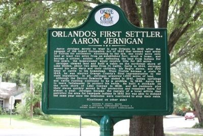 Have a great vacation! I hope it’s relaxing and rejuvenating. And (at least a little bit) educational. I plan to find the marker in Orlando where Orlando’s first settler, Aaron Jernigan built his home. Because.....well ...... history. And geography.
If you learn something awesome about where you live, work or travel -- let me know! I’m always interested! Drop me an email newmantr@pcsb.org
-Tracy
No comments:
Post a Comment